The Upper Burdekin project highlighted the complexity of the basalt aquifers, located west of Townsville in north Queensland, with many features contributing to their heterogeneous and anisotropic character.
The Burdekin River becomes perennial close to its headwaters, near the McBride Basalt Province. The McBride and Nulla basalt provinces contain groundwater resources that support domestic and stock water use, and minor irrigation. They also support groundwater-dependent ecosystems and contribute baseflow to the Burdekin River and its tributaries. An enhanced understanding of groundwater systems within these basalt provinces will assist in managing increased demand for groundwater resources in the area.
Key findings
The geometry of lava emplacement strongly influences groundwater flow regimes within each basalt province. The McBride Basalt Province is approximately circular in plan, with regional groundwater flow radially from the central high-elevation areas towards the province boundary. In the elongated Nulla Basalt Province, groundwater generally flows eastwards from the elevated areas in the west toward the province boundary. Groundwater levels have been declining since 2011 in both provinces following major flooding in Queensland during the 2010-11 La Niña weather event. This indicates that the monitoring period for this project covers a small fraction of a much longer dynamic groundwater system.
The groundwater systems of the McBride and Nulla basalt provinces are mostly unconfined and hydraulically disconnected from underlying Paleozoic-Proterozoic basement rocks. These may act as a connected system across the province, and some local-scale variations may separate groundwater flowpaths.
Natural groundwater discharge from the basalt aquifers occurs via springs, spring-fed creeks and direct aquifer discharge. This provides a reliable input to the Burdekin River and supports a variety of groundwater-dependent ecosystems.
Key findings include:
- New insights into the regional hydrogeology highlight the groundwater characteristics of the aquifers in the Nulla and McBride basalt provinces and their interactions with rivers and groundwater-dependent ecosystems. These key findings are presented in the reports and other publications listed below.
- New baseline information includes geological, hydrogeological and geophysical data. These help to map and characterise the groundwater systems. These data have been provided to Queensland water managers, and released for open access via the Geoscience Australia Data Portal.
- New airborne LiDAR elevation survey data is available via Geoscience Australia's Elvis Data Portal.
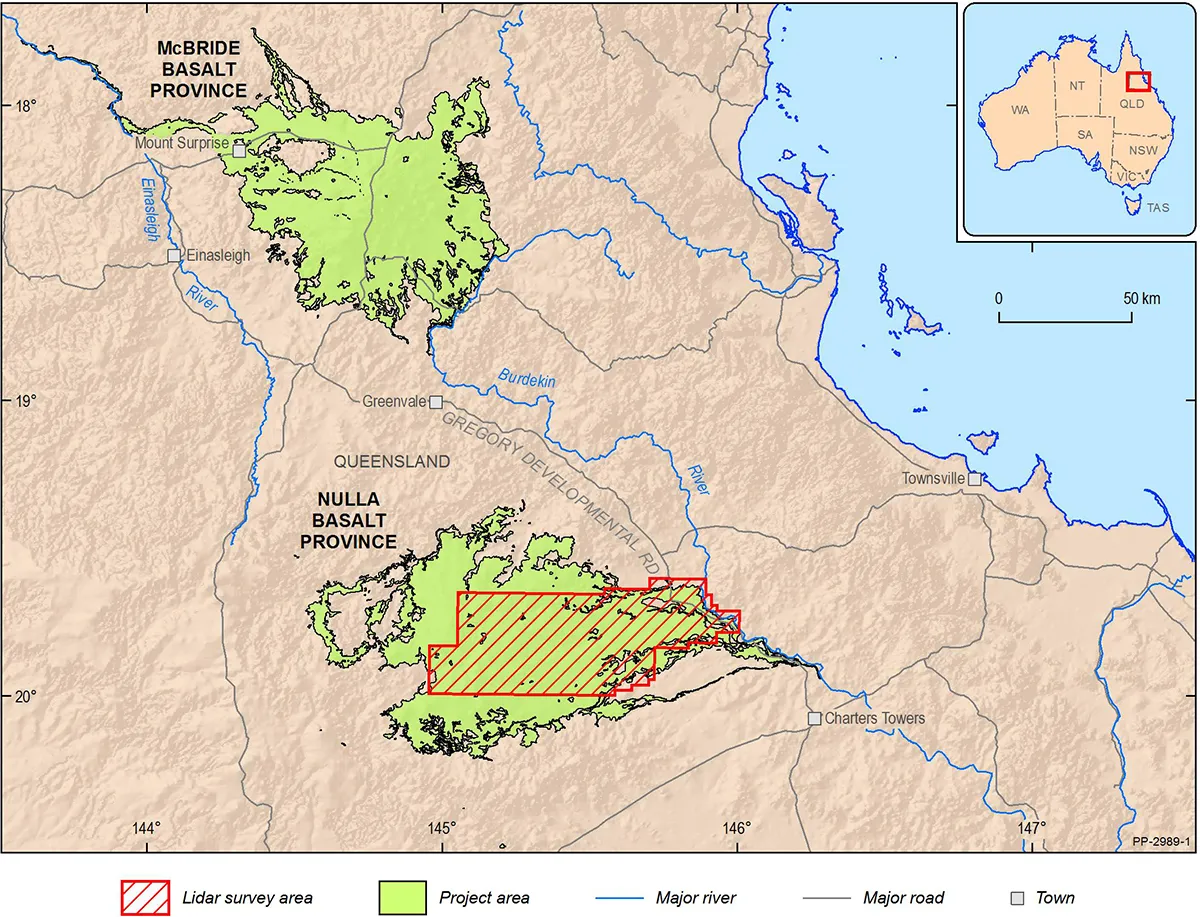
Upper Burdekin LiDAR survey area in northern Queensland. The survey data has helped better understand the groundwater resources in the region and guide future developments
Collaboration
Project collaborators included:
- North Queensland Dry Tropics
- James Cook University Centre for Tropical Water and Aquatic Ecosystem Research
- Queensland Department of Natural Resources, Mines and Energy (now the Queensland Department of Regional Development, Manufacturing and Water)
- Queensland Department of Environment and Science
- Queensland Department of National Parks, Sports and Racing
- Charters Towers Regional Council
- Tablelands Regional Council
- Local landholders
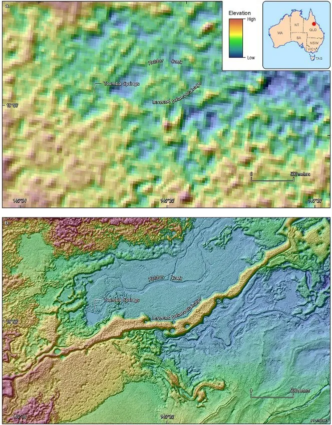
The image shows the dramatic contrast between the best elevation data previously available (top image), and the newly acquired detailed LiDAR data. The new data is sufficiently detailed to identify small drainage lines leading to springs, the surface texture of the exposed rock outcrops and pastoral tracks
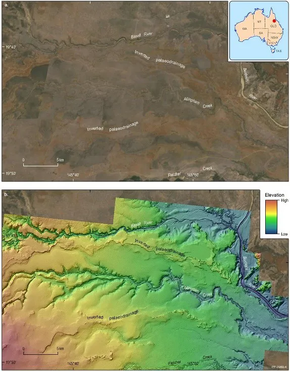
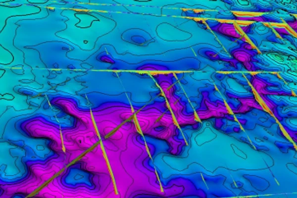
The LiDAR data reveals details of the land surface that are difficult to detect using traditional imagery. This image shows where and how lava flowed over the landscape throughout the past 4 million years. For example, 'inverted palaeodrainage' lines are a result of lava that has flowed down rivers that existed at the time of volcanic eruption. This is important to know from a groundwater perspective as beneath these features the original river sediments may be preserved and contain groundwater supplies. Base map a. source: Esri, DigitalGlobe, GeoEye, Earthstar Geographics, CNES/Airbus DS, USDA, USGS, AeroGRID, IGN, and the GIS User Community
Outputs
New data acquisition
During the project, data acquisition included:
- investigative groundwater drilling, with 17 bores drilled at 13 sites across both basalt provinces for a total of 943 m
- 15 of the bores were constructed as monitoring sites
- water samples were collected and analysed for hydrochemical and isotopic compositions, with 34 samples from bores, 78 samples from rivers, creeks and springs and 5 samples from rainfall collectors
- data loggers were installed at 24 sites (in new and existing bores) to acquire groundwater pressure data to convert to water levels
- an airborne survey covering 3,400 km2 of the Nulla Basalt Province provided for high-resolution elevation data via Light Detection and Ranging (lidar), and accompanying visible imagery.