AusAEM is the largest airborne electromagnetic (AEM) survey ever undertaken.
The Exploring for the Future program's AusAEM project was a series of national airborne electromagnetic surveying programs, with the ultimate goal of covering the entire continent at a line-spacing of ~20 km. Since 2017, the program had seen several rounds of acquisition, with national coverage continuing to be extended across the continent.
What is AEM?
AEM is a non-invasive testing technique that can measure variations in the conductivity of the ground to a depth of several hundred metres. The conductivity response of the ground is commonly caused by the presence of electrically conductive materials, such as salt or saline water, graphite, clays and sulphide minerals.
- Watch an animation on How AEM surveys work (1:28 min)
Using the data
AusAEM data and derived products are used to map the thickness and character of sedimentary and regolith cover. The survey results are also used to assess the potential for groundwater resources in Australia's arid zones to support remote communities in the survey areas.
Regional models derived from AEM data of subsurface electrical conductivity show new undercover geological features that could host mineral deposits, including critical minerals, and groundwater resources. The models enable us to map potential alteration and structural zones and support environmental and land management studies. Several features observed in the AEM models have also provided insights into possible salt distribution that may have potential for hydrogen storage.
When combined with earlier data and the more recent Western Resources Corridor acquisition program (see map below), Western Australia was the first state to reach 100% coverage at 20 km line-spacing.
As of March 2023, all acquisition programs were completed (see the map below).
| Survey | Jurisdiction/s | Funding | Completed |
|---|---|---|---|
| AusAEM1 | QLD, NT | Exploring for the Future | 2018 |
| AusAEM2 | NT, WA | Exploring for the Future | 2019 |
| Eastern Resources Corridor | QLD, SA, NSW, VIC | Exploring for the Future | 2021 |
| AusAEM20-WA | WA | WA Exploration Incentive Scheme Exploring for the Future | 2022 |
| Western Resources Corridor | SA, NT, WA | Exploring for the Future WA Exploration Incentive Scheme | 2022 |
Along with AusAEM1 and 2, the precompetitive regional AEM approach can be traced back to 2006 when Geoscience Australia's Onshore Energy Security Program (OESP) 5-year program was designed to reduce risk in exploration and support development of Australia's onshore energy resources. This saw the acquisition of 65,000 line km of wide-spaced (5km) AEM across northern Australia for energy and minerals. This acquisition was notable for identifying the strengths of the technique in being able to provide high-resolution mapping under cover to depths of 100s of meters.
Data for the completed AusAEM programs are publicly available from Geoscience Australia's product catalogue:
- AusAEM1
- AusAEM2
- Aus AEM 20
- AusAEM-WA, Murchison Airborne Electromagnetic Survey Blocks
- AusAEM-WA, Southwest-Albany Airborne Electromagnetic Survey Blocks
- AusAEM WA 2020-21, Eastern Goldfields & East Yilgarn Airborne Electromagnetic Survey Blocks TEMPEST airborne electromagnetic data and GALEI conductivity estimates
- AusAEM (WA) 2020-21, Earaheedy & Desert Strip Airborne Electromagnetic Survey Blocks TEMPEST airborne electromagnetic data and GALEI conductivity estimates
- AusAEM Eastern Resources Corridor
- AusAEM Western Resources Corridor
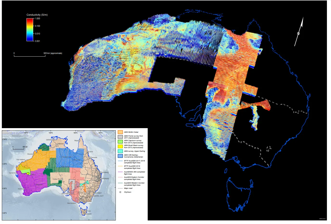
Geoscience Australia, with our partner state and territory geological surveys, have systematically acquired and merged geophysical surveys to cover most of the Australian continent
Geoscience Australia, with our partner state and territory geological surveys, systematically acquired and merged geophysical surveys to cover most of the Australian continent.
More about airborne electromagnetics
Collaboration
Along with funding from the Australian Government's Exploring for the Future program, the AusAEM program was expanded with funding from the Geological Surveys of Western Australia, NSW and Queensland, combined with valuable in-kind support from all Australian state and territory governments and their geological surveys. Geoscience Australia acknowledges all landholders and communities who support our work in rural, regional, and remote Australia to produce these datasets.
Outputs
The data and Geoscience Australia's conductivity-depth layered earth inversions from AusAEM are freely available from the Geoscience Australia's Data and Publications search.
The data release packages contain the final deliverables produced by multiple contractors, including:
- the survey logistics and processing report
- final processed electromagnetic, magnetic and elevation point located line data
- final processed electromagnetic, magnetic and elevation grids
- conductivity estimates generated by the contractor's preferred conductivity depth imaging algorithm
- graphical multipoles of line data and conductivity sections
- graphical stacked conductivity sections.


