Project Groundwater
As such, the Groundwater Sector plays a critical role in national water security, contributing $6.8 billion per year to Gross Domestic Product (GDP). Groundwater represents 17% of available fresh water in Australia and is essential for providing increased supply during periods of drought for agriculture and community consumption in many parts of the country. In addition, many mineral and energy deposits occur in remote areas where groundwater is the only secure water source.
During the period from 2016 to 2020, Geoscience Australia's Exploring for the Future program focused on northern Australia. In northern Australia, groundwater resources and water banking/aquifer storage provide significant opportunity for economic expansion due to the seasonal limitations of surface water flows, the limited availability of surface dam sites, and high evaporation rates that rapidly deplete surface water storages. Harnessing these groundwater opportunities requires thorough investigation of groundwater systems and resources.
1 Deloitte Access Economics, National Centre for Groundwater Research and Training, October 2013,
Economic value of groundwater in Australia.
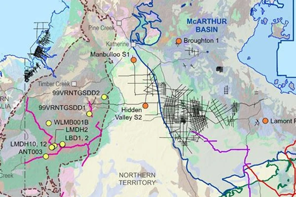
Five regional areas were selected for targeted geoscience studies in East Kimberley, Northern Stuart Corridor (Howard East and Daly River Basin), Southern Stuart Corridor (Tennant Creek to Alice Springs), Upper Burdekin (Nulla and McBride basalt provinces), and the Surat and Galilee basins.
The current Exploring for the Future (2020-24) program continues regional groundwater studies with a broadened focus to improve a national understanding of groundwater systems. These studies are included in the Darling-Curnamona-Delamerian and Officer-Musgrave deep-dive projects.
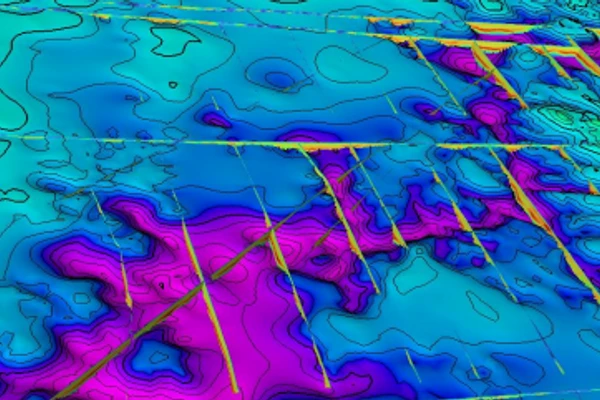
The regional groundwater investigations involved the collection, interpretation and delivery of a range of new pre-competitive hydrogeological, geophysical, geospatial and remote sensing datasets to map the near-surface geology and groundwater systems, and assess potential salinity hazards associated with resource development.
This project built a greater understanding of groundwater systems in the onshore Bonaparte Basin within the Keep River Plains in the Northern Territory (NT) to enable informed decision-making for agricultural development. (Completed project 2021)
Visit the East Kimberley project page to learn more.
This project investigated areas around the northern half of the Northern Territory close to the Stuart Highway. It included 2 project areas: the Daly River Basin and Howard East area, selected due to their high-value groundwater resources. (Completed project 2021)
Visit the Northern Stuart Corridor project page learn more.
This project focused on 4 water management areas in the Northern Territory:
Outside of these water management areas, the project investigated potential groundwater supplies for several remote communities. (Completed project 2021)
Visit the Southern Stuart Corridor project page to learn more.
This project highlighted the complexity of the basalt aquifers, located west of Townsville in north Queensland, with many features contributing to their heterogeneous and anisotropic character. (Completed project 2021)
Visit the Upper Burdekin project page to learn more.
This project collected airborne electromagnetic (AEM) data across 2 areas in Queensland, including parts of the Surat and Galilee geological basins. These data were released for inclusion in future studies and have been combined with other geophysical and geological data to characterise aquifer architecture in the Australian Government funded project 'Assessing the Status of Groundwater in the Great Artesian Basin'. (Completed project 2021)
Visit the Surat and Galilee Basins project page to learn more.
Geoscience Australia collaborated with a range of stakeholders, including Commonwealth, state and territory government agencies, local councils, pastoral leaseholders, local Indigenous groups and Land Councils.

Walsh, C., Buckerfield, S., Raiber, M., Suckow, A. (2024)
Peljo, M., Tan, K., Symington, N., DeGraaf, R., Ross Spulak (2024)
Informing resource development projects across Australia.